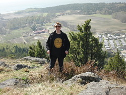
Photo. Admiring the beautiful scenery on the top of Bjørnåsen, Jeløy, Jeløya, Moss in Norway. Both the names Jeløy and Jeløya can be used. © Travel Explorations.
On Jeløy today there are no spectacular eruptions, no bubbles and steams with volcanic activity, or no view lava flowing into the sea. Anyway I was thinking about what happened for 280 million years ago when the island`s unique landscape was shaped by volcanic activity.
It must have been pretty dramatic at that time when Jeløy was shaped. First of all I will say the creation was wonderful. Don`t worry there is no dormant volcanic there today.
Jeløya is actually a peninsula in the Oslo Fjord. It`s a part of the Moss, which is a coastal city and a municipality in Østfold county, Norway. The Moss region has an abundance of trails and paths, especially on Jeløy. This beautiful island is located around 60 kilometers from Norway`s capital Oslo. Jeløy covers 19 km² and is the largest island in the Oslo fjord. It has about 12,000 inhabitants.
Jeløy is today also known for its good fishing opportunities, exciting biking trails, caves, nice beaches, a pulsating harbor with boats, open farms for visitors with cafèes, horseriding and arts, especially at Gallery F15 at Alby where you find one of Norway's most widely known art galleries. Jeløy is very popular for visitors both in the summer and winter. Many families and friends go there on picnic.
Jeløy belongs geologically to the Oslo area, and is made up of a young lava rock-type from the Permian period. On Jeløy there are three tall peaks. Bjørnåsen, Bjornasen (the Bear Hill in English) reaches 138 metres high and is the tallest (or it`s Rambergåsen?). It`s situated straight up and east of Nes Camping on the northern part of the island. From the tower on top of the hill it`s a breathtaking view in all directions. It`s possible to park at the farm at upper Skallerød Renneflotveien.
The other two peaks on Jeløy are Rødsåsen, Rodsasen, and Ramberåsen, Rambergasen, Ramber Hill. Rødsåsen is 70 meter tall and is located in the southern part of Jeløy. The nearest parking is at Alby or Røed Gård.
Rambergåsen, called Ramberg Hill in English, rises 140 metres above ocean. The nearest parking can be found by following Rambergveien up past Jeløy Church to where it`s forest on both sides of the road.
Many ways leads to Rome. It`s the same with the peak of Bjørnåsen on Jeløy. On sunny Sunday 24th April, 1st Easter day 2011, I and my daughter Sanna considered to start from many places. We couldn’t see any signs so we were not sure where we could start our ascending to the top. The nice locals we met on our way told us were we should go. After a while we finally found a trail from the road Reneflotveien where we could start from. This trail was not so long to walk and not too steep to climb. We parked our car near the trail, and so our hiking begun. Since the area is known to host the poisoned snake Hoggorm, we used boots to protect us. The boots were also good for mastering the steep terrain.
|
Photo. A strange tree near the top of Bjørnåsen. Modern art made by Mother Nature itself at Jeløy, Jeløya, Moss in Norway.
© Travel Explorations.
|
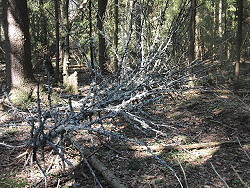 |
We started on a trail from the other side of the mountain for Nes Camping, and it took about 30-40 minutes to walk up to the summit, but it possible to make in shorter time if you find the right trail. We followed a partly unmarked trail into the dense forest with spruce, pine birch and other species of wood. Some parts were quite spooky. It was like a fairytale forest with steep, rocky and narrow trails. Sometimes we have to step over mud, fallen trees, big stones and roots. On our way to the top we could admire some strange creations from Mother Nature through various kinds of landscapes. There were also plenty of beautiful wild flowers there and the birds were singing happily for the spring.
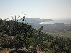
From the summit we enjoyed the beautiful view of the Oslo Fjord and the beautiful coastline. Down under us we could also observe Nes camping and the cultivated area Vestre Nes.
| Photo. Admiring the beautiful scenery on the top of Bjørnåsen, Jeløy, Jeløya, Moss in Norway. © Travel Explorations. |
 |
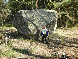
We also watch a big rock standing alone on the top, which we thought was strange. How did that big rock end up there? The forces of volcanic activities?
|
Photo. A big rock on the top of Bjørnåsen, Jeløy, Jeløya, Moss in Norway. How was the rock placed there?
© Travel Explorations.
|
 |
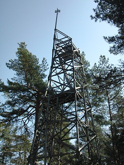
Hidden in the forest on the top there is a watch tower built by Germans soldiers during the Second World War. I didn`t dare to climb up the tower since the construction looked pretty rotten and unstable, but for they who dare to climb up there, will achieve an amazing panorama view over the island and coastline.
|
Photo. A watch tower built by Germans soldiers during the Second World War at the top of Bjørnåsen, Jeløy, Jeløya, Moss in Norway.
© Travel Explorations.
|
 |
It was easy to get lost. A person I met on the top that told me that he had got lost many times near the top of Bjørnåsen. It`s a lybriant of paths around there which can make you fairly confused. Sometimes it was difficult for us to stay on the right track down again. We lost it one time, but fortunately we found a short cut to our car.
Stein Morten Lund, 24 April 2011
Additional information
Transportation:
In the autumn of 2007, the military airport called Rygge just outside Moss was converted into a civil airport. Moss Airport, Rygge received the IATA code RYG. The project initially started in 1992 was dubbed RSL an acronym for Rygge sivile lufthavn, Rygge civilian airport. Today Ryanair offers many flights to this airport from several destination in Europe.
A ferry line (the Bastø Ferry) across the Oslo Fjord runs between Moss and Horten in Vestfold.
Read more about the Moss region in Norway on our global travel guide Travel Explorations.


