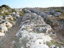
Photo. The mysterious cart ruts in Malta`s barren landscape. © Travel Explorations.
Up to this day the cart ruts have remained an unsolved enigma to all scientists who tried to explain their purpose and function. Several hypotheses have been suggested, but no completely theory has been made and common accepted. All theories are based on assumptions and limited evidence.
By the sunset I explored the carts ruts. The tracks were illuminated by the sun rays. After a while some of the deepest tracks become dark because the sun rays couldn`t reach them. It felt strange walking in these tracks. It was like walking in the shadow on a barren plain. View the video clip of the amazing tracks: The mysterious Cart Ruts.
One of the theories is that the ruts were worn by heavy carts or sledges, moving tons of stone miles across the landscape.
The wildest theory is that the tracks are caused of outer space landing crafts, or are coded messages to the gods scrawled in runes across the landscape.
Some of the cart ruts go straight into the sea, and other ruts go to the edge of cliffs with a sheer drop of 30 – 35 metres to the sea. Due to this someone believe that Malta was the lost Atlantis.
Who knows? I still wonder why the tracks were made and of who?
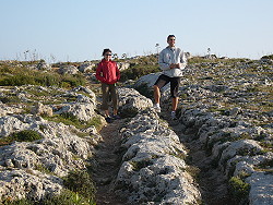
Photo. The mysterious Cart Ruts studied by some eager explorers.
© Travel Explorations. |  |
Most archaeologists believe that the site developed about 2000 BC after immigrants came over from Sicily to start the Bronze Age in Malta.
The name "Clapham Junction" was given by an Englishman, who later reported that it reminded him of the great and busy railway station Clapham Junction in London. Clapham Junction is a railway station located in Battersea in the London Borough of Wandsworth. It is situated on St. John's Hill in the south west of Battersea and in an area now commonly known as Clapham Junction; a reflection of the influence the station has upon its locality.
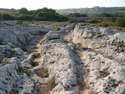
Photo. A traffic jam in the Maltese highland. The carts ruts can easily wake associations with the railway station Clapham Junction, and other railway stations in London too.
© Travel Explorations. |  |
The tracks are about 50 cm deep and have an average distance of 110 to 140 cm. Some are crossing, and other build junctions. This makes the illusion of a great railway station.
There are some more theories about the purpose of these tracks. The most discussed are the followings:
- Goods were transported here on sledges which gouged the tracks into the rock.
- The tracks are real cart ruts for transporting goods.
- It is an irrigation system.
The both theories of the transport system are the most popular in the discussion. Both have provoked some questions which have not been answered yet. If it were sledges so the goods moved would have to be quite heavy to produce such deep tracks, therefore they needed a very huge power to be moved: Malta is a small island with a relatively small population at that time. To fit, carts with wheels would have had to have wheels with a diameter of 1.4 meters = 4 feet 9 inches at least.
Another (similar) theory says that the huge blocks of limestone had been transported here, used to build the temples. The problem is that the ruts can be found at many places but not near to the temples. The irrigation system theory tries to explain the tracks by the fact, that the stony soil at that time was quite infertile. It was more and more difficult to provide the population with food, so that irrigation got necessary.
Other explainations abou the tracks:
The Maltese archaeologist Anthony Bonann believe that the ruts are devices of the Phoenicians, which would mean that the tracks were made quite later, in the 7th century BC. But it is known that the activities of the Phoenicians on Malta were quite small. Other theories try to prove that Malta is the ancient Atlantis. The world famous Swiss scientist Erich von Däniken, who have studied the carts, thinks that they are runways for take-offs and landings of extraterrestrial visitors.
By observing and walking in these criss cross of parallel grooves, it gave me a hard puzzle to solve. It`s no doubt that this is an unique archaeological heritage. These paired, parallel tracks can be found in about one hundred and fifty sites across the Maltese islands. Similar tracks are also found in other countries such as Greece, Sardinia, Italy and Sicily. They occur in in greatest number on the Maltese Islands. It`s common perception that the cart ruts are the result of human activity. Are the ruts showing the last evidence for a transport network in the past, or are they made for another purpose?
Stein Morten Lund, 31 May 2006
Additional information
Some of the information in this article is based on several sources. One of the most important sources for background information is Wikipedia.
Historical sights in Malta:
1 National Museum of Archaeology,Valletta
2 Tarxien Temples (2700 – 2000 BC) – Tarxien
3 Hal Saflieni Hypogeum (circa 3000 BC), Paola
4 Ghar Dalam Cave and Museum (circa 5000 BC)
5 Borg in-Nadur Temple
6 Hagar Qim and Mnajdra Temples (3200 BC)
7 St. Paul’s Catacombs, Rabat
8 St. Agatha’s Catacombs, Rabat
9 Museum of Roman History and Antiquities – The Roman Villa
10 Clapham Junction (cart ruts)
11 Cart ruts at San Pawl tat-Targa
12 Roman remains and church at San Pawl Milqi
13 Roman Baths
14 Ta’ Hagrat Temples in Gozo
15 Museum of Archaeology - Victoria
16 Ggantija Temples, Xaghra
17 Brocktorff Circle


